
Page 66 - 2023 OUTLINE OF THE MINISTRY OF THE INTERIOR REPUBLIC OF CHINA
P. 66
Land Administration
and rural development, offshore island construction, space technology development, geosciences,
resource exploration, oceanography science, military security, and fault monitoring, etc. In 2022, 3,026
applications for data have been examined and approved (See Table 5-12).
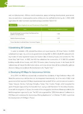
Table 5-12 Data Applications and Provisions in Fiscal 2022
Item Recognized Applications (Cases)
Raw and Exchange Format of Daily Files Received from 1 945
Satellite Tracking Stations
Satellite Positioning Surveys 1 077
Taiwan Geodesic Coordinate Datum Conversion Program 4
5.Establishing 3D Cadaster
In order to establish a 3D cadastral foundation and move towards a 3D Smart Nation, the MOI
subsidized municipal, city, and county governments during 2021 to 2025 to build 3D cadastral build-
ing models of newly registered houses and location data of existing houses, and convene the "Na-
tional Map Task Force". In 2022, the MOI has subsidized the construction of 121,862 3D cadastral
building models of new houses, and 1,876,718 location data of existing houses. In the future, the 3D
national map will import the information above, and cross-domain data will be combined to optimize
decision-making and accelerate the development of a "Digital Twin."
6. Developing HD Maps for Autonomous Vehicles
Since 2019, the MOI has successively completed the standards of High-Definition Maps (HD
Maps) for autonomous vehicles that can be integrated internationally. As of the end of 2022, local
governments had reported HD Maps requirements that reached 142 km, and the sites are located in
Taipei, Taoyuan, Hsinchu, Taichung, Changhua, Tainan, Yilan, Hualien, Penghu, which exceeded the
goals of the plan approved by the Executive Yuan. Laying a solid foundation for the safety of autono-
mous vehicle navigation in Taiwan, the results of the cartographic data have all been provided to the
field management agencies for use. The MOI also organized the “2022 International Conference on
HD Maps and Localization for Autonomous Driving Applications” on October 19 ,2022, to promote
the development of HD Maps in Taiwan.
64